“For the love of God, everyone please just stay home tomorrow!” Well, shit, I was both relieved and upset I had decided to open Facebook on Friday, October 14th. After out-of-nowhere rainfall, water crossings were going to be disastrous particularly in the Pemigewasset, and this was not promising to someone whose fallen into multiple rivers over a hiking career.

The problem with this realization is that Michelle had just driven three-and-a-half hours up from Boston to do the Bonds, as many had planned on doing this weekend. With the ever-growing disappointment that the Bonds just weren't going to happen, I scrambled to pull together routes that would prevent us from drowning. But, with the Bonds now out of the question, I started looking for something that would be mutually beneficial to three people working on three different projects: The NH48, The Trace/NE Hundred Highest, and the NH Hundred Highest. Turning my focus to the North Country for less violent water crossings, we all had some unfinished business in the Pilot Range.
When I did Cabot for my initial run of the forty-eight, I was with a clan of 15-year-old boys who had no interest in doing more than the bare minimum, which left us to an out-and-back up Bunnell & Kilkenny. This time was going to be different. This time we were going to bag six peaks, at least one for each of us, and some new trails.

With the change of plans, we pushed our start time back and got going around 8:45 am. We were the tenth car there in the morning but didn’t see anyone else until several hours into the day. The three of us got started up Unknown Pond Trail, which I had yet to see the likes of, and it had three water crossings that I would imagine are usually rock hops. But today, simple crossings required some effort to avoid getting wet.

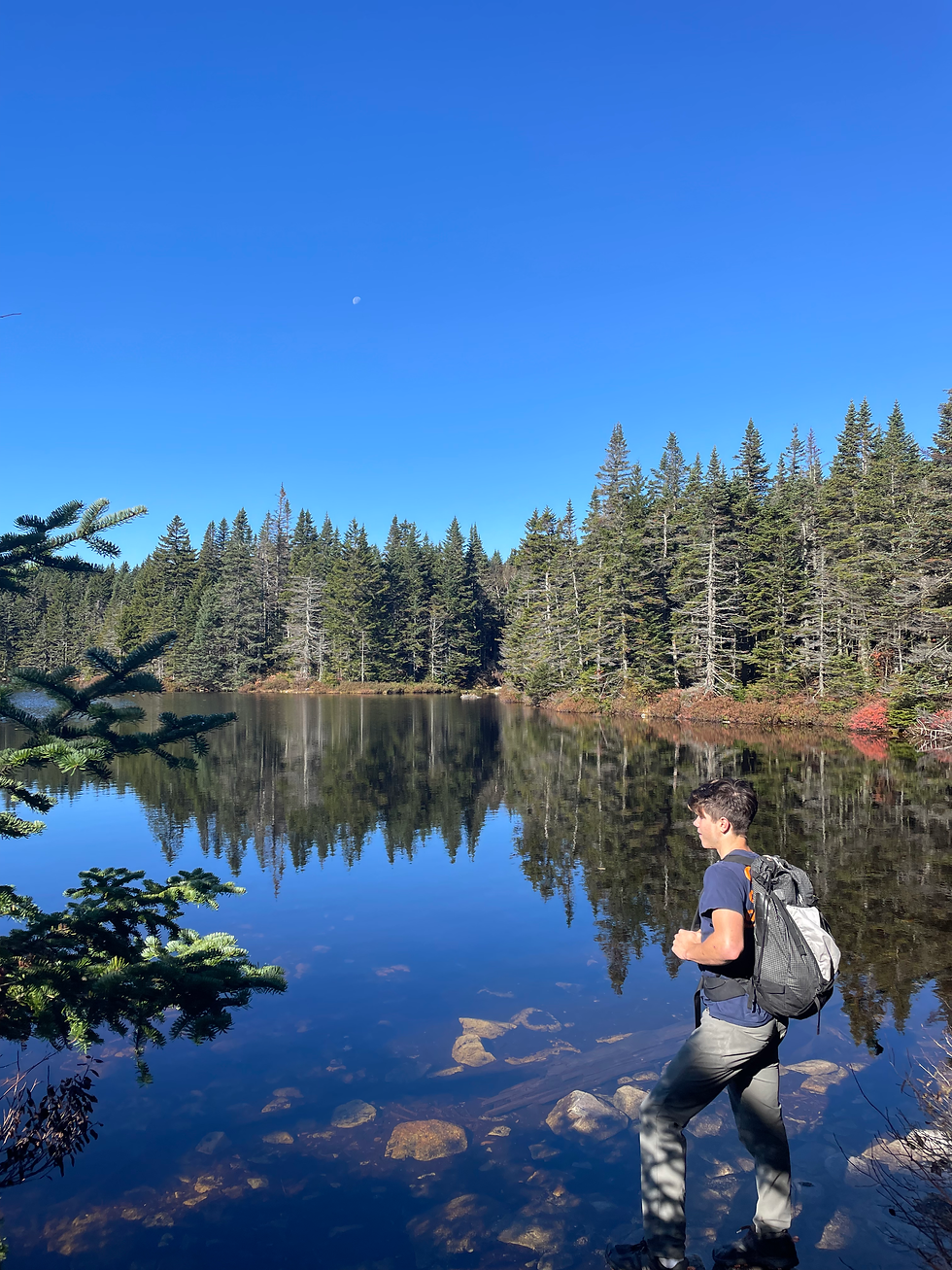
Towards the top of Unknown Pond Trail, we passed the foliage-rich forest and made our way into a somewhat open spruce forest that stayed close to the stream for most of the way up. At this point, we heard an alarming shuttering noise, and out of the corner of our eyes noticed that it was a spruce grouse- we ended up hearing this sound another three or four times throughout the day. When we got to the height of land on Unknown, we checked out the beautiful and very spacious tent site before going down to Unknown Pond, which the moon was still overlooking.
Once we got on Kilkenny, we made quick work over to The Horn which has a 0.3 mile-spur, labeled by a sign that has been defaced to say, “The Horny.” The last push-up to the top is a bit of a throw your whole body over a rock moment, but if you go around the backside of the rocky top you can avoid such an embarrassment of a scramble. From the summit, we were delighted to see views of the Presidential Range, the Carters, the Percy Peaks, and a bunch of other ranges we were all well-versed in. Thankfully, we had packed food well and enjoyed bacon, cheese, and prosciutto on the summit. We are of the firm belief that it is always important to treat yourselves on big days.


After the Horn, we hit the Bulge and this portion of the ridge was pretty easy on the feet, not too wet, and absent of the slippery leaves that we dealt with at lower elevations. Cabot came easy as well, as we only had a 200-foot (raw) elevation difference between the Bulge and Cabot. At the summit, we found three friendly gray jays, a tiny cairn, and Michelle hitting 31/48 on her project!


Just past the summit, when we got to the small viewpoint by the cabin and we ran into a man who we fortunately got to direct to the actual summit. Past him, within the cabin, I was surprised to see it had been spruced up and repainted since my last visit about a year and a half ago. But, after experiencing how far the Cabot Spring Spur goes down for the sake of tracing it, I would not want to be staying at this cabin and be reliant on such a long descent to the water.


Looking at our watches, we didn't wait too long at the cabin as we had a lot of ground left to cover and a lot less daylight than we're accustomed to working with. From the cabin until the junction with the abandoned Mt. Cabot Trail, Kilkenny descended steeply and seepy. Shortly after the junction with the old Mt. Cabot Trail, we got to our (not abandoned) junction and made the call to adhere to my original plan rather than taking the shorter and safer way out to ensure a sunlit finish.
With a little bit of self-convincing that venturing over the Terraces was still a good idea, we kept on Kilkenny which looked like a different trail as we moved to the portion that only through-hikers and NH Hundred Highest peak baggers use.

Though less utilized, the trail was never hard to follow and immensely rich in mosses, most unlike anything I’d ever seen before. With the smooth roll over the three Terrace peaks coming easily each time, this stretch was my favorite of the entire day. About a mile past the junction from Bunnell, we got incredible views of a talus slope on Cabot, which surprised all of us as Ryan had always assumed Cabot was no more than a “friendly dome.”

The summit of Terrace, which claimed to be a 0.1-mile spur, was probably around a fourth of a mile and only lent to very slight views of the North Country. Regardless, we were all happy to be there and happier that we were doing pretty well on time.

From the last Terrace, we had just over an hour of daylight left which was growing worrisome to me as we had to step so carefully down the side hill that Kilkenny had to offer. Despite being well-outfitted and in the possession of several headlamps, hiking in the dark still is not my favorite after some hallucination incidents earlier in the season.

After a lot of careful steps down the hill, we entered Willard Notch which soon lent its way to the York Pond Trail. At this point, we had forty minutes of daylight, 2.4 miles, and 1000 feet to drop. Not bad at all.
York Pond Trail flew by and even though it was thickly covered in leaves, there wasn’t anything too hazardous underneath them to warrant turtle speeds. At the very end of the trail, there were 3 water crossings. The first was easily crossable if you don’t hate water crossings (I walked straight through it), the second required a bit of a jump to the thick birch roots across the stream, and the last was bridged with a dam to walk over.


After the dam, all we had left was a few big bridges through a grassy area, and by the time we hit the junction with Bunnell Notch once more, we were on the home stretch and the sun had only been set for 5 minutes.
Still worried about the gate being locked, we were relieved to see a car come in and drop someone off. But then it hit that it didn't make sense to see someone dropped off after dark.
When we got closer, the man yelled out to us to ask if we had just gotten down. We told him we’d gone the long way and expected to be down this late. But then we recognized him, it was the same guy we’d seen at the Cabin lookout.
Through a conversation entirely built on shouting, he told us he’d realized he might have made the wrong turn when he saw the sun going down on the wrong side. But, he couldn’t turn around because he saw a massive bear right in his path. Thankfully, he’d gotten a 45-minute ride back to York Pond Road from a cabin-owner on the west side of the ridge. I don't mention this to shame him, as I did my entire 48 without a GPS (regret it), but to encourage everybody to hike with some sort of tracker, whether it be a $20 app or a $500 satellite communicator, it makes life better to have one.

When we got back to the Jeep, I changed out of my soaking trail runners and we headed back to Lyndon to bake cast iron skillet mac and cheese while reflecting on the day the three of us had. And to plan the next day of course.
Σχόλια